Accumulations have long been a menace for the portfolios of transport insurers worldwide and climate change is now making this issue more relevant than ever before. At the same time, we have long been observing an increasing concentration of risks in coastal regions, where risk exposure is naturally greater than it is inland.
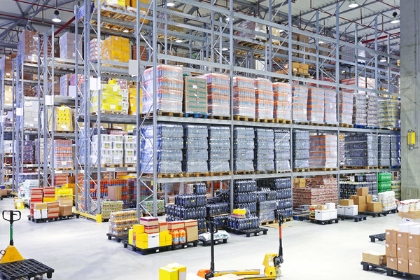
Alongside ships, which have taken on dimensions that many people are unable to imagine, it is warehouses that contain the most worrying accumulations. Ships are usually affected in isolation by loss events, but is the same also true for warehouses? From the risk perspective, they are actually very different and must occupy locations offering good transport access, preferably at multimodal hubs where railway, motorway, river and maritime routes converge. They must be as secure as Fort Knox and be protected – if at all possible – from exposure to any natural hazards, while continuing to guarantee smooth-running logistics processes all day, every day. These requirements are inherently contradictory and, indeed, promote higher levels of exposure to natural hazards. The result is that the focus is placed first and foremost on functional aspects and many warehouse locations are consequently obliged to make compromises.
During the last 20 years, so-called “logistics centres” have increasingly become established on the outskirts of major cities and in themselves create value-add. The availability of specific services and strategically organized intermodal transport connections exert a special attraction for logistics companies. Effects of scale mean that warehouse dimensions are growing almost without limits. This focus on logistical and economic criteria means that accumulations have grown unnoticed on a scale never witnessed in the past.
IUMI’s statistics on major losses provide a very clear picture of loss and damage at warehouses. In some years, they account for up to 60 % of all losses. However, even in years when they are not so badly affected, warehouse losses nevertheless constitute a significant proportion of major losses. We do not know if these risks are taken into account in the underwriters’ calculations. We can only assume that the risk is frequently underestimated; because it is not obviously visible, it is necessary to search for it.
At this point, let us raise the underlying question: What actually is an accumulation? Is it a large ship or a warehouse, is it multiple warehouse facilities grouped together in close proximity and therefore all contributing and exposed to a mutually shared risk, or does the term need to be interpreted differently from the risk perspective? The answer is obvious: Natural hazards can threaten huge areas in their entirety, sometimes amounting to several thousand square kilometers. The areas exposed to the same hazards determine the risk. Anyone who does not know what these areas are and the risk locations they contain is flying blind. That is something no one could afford to do in the past and it is all the more unthinkable given the size of today’s storage locations and the value of the assets they contain.
More than 10 years ago, the German market decided to respond to this problem by entrusting its association with the task of developing an underwriting and accumulation tool to put an end to this lack of knowledge. Solvency II increased the pressure to act. “Know your risk” was the watchword, because cyclones and tsunamis can lay waste not only to whole tracts of land but also to balance sheets. Working together with the association’s members, the GDV’s Marine Department spent several years developing the tool known as the “Kumul Information Service” (KIS), which is of use not only for underwriting activities but also, and particularly, for the monitoring of accumulations. KIS takes account of multiple threats which can be combined as required by the user because, for example, a cyclone causes not only storm-related damage but also floods due to heavy rain and coastal storm flooding. It is vitally important to know one’s portfolio and understand where the risks are located. This transparency is a basic prerequisite for responsible underwriting and accumulation management.
KIS contains nine global hazard maps ranging from tsunamis through to winter storms in Europe and from cyclones through to earthquakes. Two hazard maps are devoted to political risks, one at national level and another, more detailed, at up to regional level. Individual risks can be queried to permit rapid analyses; however, it is also possible to perform the continuous, accumulation-related monitoring of hundreds or thousands of risks. Thus it is no longer possible to lose sight of any individual risk and everything stays under control.
It is not just the climate that is changing; so, too, is the general political situation. We cannot change these facts but we must adapt to them and make sure that accumulations are subject to the necessary control. KIS can be used by anyone. It is neutral and its only loyalty is to the accuracy of its contents. Its functioning is not profit-oriented and it aims only to continuously improve in quality.